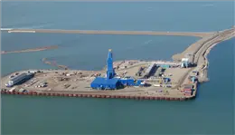
Prudhoe Bay, Alaska

Back to Alaska Photos

P1040928.jpg
Stevens Village, Alaska

8/3/2010 12:52:29 PM
Altitude 16,904 ft (5,152 m)
-map-
P1040931.jpg
Brooks Range, north of the timberline

8/3/2010 1:21:48 PM
P1040933.jpg
The north side of the Brooks Range

8/3/2010 1:24:58 PM
Altitude 6,528 ft (1,990 m)
-map-
P1040935.jpg
The North Slope

8/3/2010 1:25:04 PM
Altitude 6,390 ft (1,948 m)
-map-
P1040937.jpg
8/3/2010 1:26:21 PM
Altitude 4,555 ft (1,388 m)
-map-
P1040939.jpg
8/3/2010 1:26:50 PM
Altitude 4,467 ft (1,361 m)
-map-
P1040944.jpg
8/3/2010 1:35:32 PM
Altitude 4,062 ft (1,238 m)
-map-
P1040951.jpg
8/3/2010 1:38:11 PM
Altitude 3,466 ft (1,057 m)
-map-
P1040955.jpg
8/3/2010 1:38:51 PM
Altitude 3,441 ft (1,049 m)
-map-
P1040958.jpg
North Slope, Alaska

8/3/2010 1:43:50 PM
Altitude 2,764 ft (842 m)
-map-
P1040959.jpg
8/3/2010 1:43:53 PM
Altitude 2,727 ft (831 m)
-map-
P1040960.jpg
Colville River, Alaska

8/3/2010 1:47:02 PM
Altitude 2,432 ft (741 m)
-map-
P1040963.jpg
Tundra Polygons

8/3/2010 2:22:15 PM
Altitude 970 ft (296 m)
-map-
P1040964.jpg
Tundra Polygons

8/3/2010 2:22:17 PM
Altitude 951 ft (290 m)
-map-
P1040966.jpg
A camp on the Price River

8/3/2010 2:23:10 PM
Altitude 919 ft (280 m)
-map-
P1040967.jpg
A camp on the Price River

8/3/2010 2:23:12 PM
Altitude 923 ft (281 m)
-map-
P1040974.jpg
Tundra

8/3/2010 2:29:08 PM
Altitude 5,693 ft (1,735 m)
-map-
P1040978.jpg
8/3/2010 2:30:06 PM
Altitude 7,152 ft (2,180 m)
-map-
P1040985.jpg
Lakes and tundra, near Barrow, Alaska

8/3/2010 2:35:49 PM
Altitude 10,710 ft (3,264 m)
-map-
P1050004.jpg
Sea Ice, 25 miles north of Barrow

8/3/2010 4:38:55 PM
Altitude 2,912 ft (888 m)
-map-
P1050006.jpg
Sea ice, north of Barrow

8/3/2010 4:39:05 PM
Altitude 2,759 ft (841 m)
-map-
P1050007.jpg
Sea ice, north of Barrow

8/3/2010 4:40:41 PM
Altitude 1,239 ft (378 m)
-map-
P1050021.jpg
Sea ice, north of Barrow

8/3/2010 4:49:36 PM
Altitude 1,765 ft (538 m)
-map-
P1050028.jpg
Sea ice, north of Barrow

8/3/2010 5:08:08 PM
Altitude 1,237 ft (377 m)
-map-
P1050067a.jpg
Northstar Island, built 1999-2001, by BP.

8/3/2010 5:55:32 PM
Altitude 1,000 ft (305 m)
-map-
P1050073a.jpg
Northstar Island, built 1999-2001, by BP.

8/3/2010 5:55:53 PM
Altitude 1,019 ft (311 m)
-map-
P1050081a.jpg
Endicott Island, and artificial island built in 1987, used by BP and Exxon.

8/3/2010 6:01:59 PM
Altitude 1,012 ft (308 m)
-map-
P1050087.jpg
BP's Liberty project is near Endicott Island. In 2011 they will drill several wells 2 miles down then 6-8 miles horizontally under the Beaufort Sea.

8/3/2010 6:03:19 PM
Altitude 1,031 ft (314 m)
-map-
P1050089.jpg
BP's Liberty project is near Endicott Island. In 2011 they will drill several wells 2 miles down then 6-8 miles horizontally under the Beaufort Sea.

8/3/2010 6:03:39 PM
Altitude 1,197 ft (365 m)
-map-
P1050092a.jpg
8/3/2010 6:07:50 PM
Altitude 1,582 ft (482 m)
-map-
P1050098.jpg
The "small boxes" are enclosures for oil wells, one well inside each box.

8/3/2010 6:10:55 PM
Altitude 1,583 ft (483 m)
-map-
P1050099.jpg
8/3/2010 6:11:01 PM
Altitude 1,563 ft (476 m)
-map-
P1050103a.jpg
P1050104.jpg
Prudhoe Bay oil wells

8/3/2010 6:11:44 PM
Altitude 1,537 ft (468 m)
-map-
P1050107.jpg
Tundra / ice truck

8/4/2010 7:45:45 AM
P1050112.jpg
8/4/2010 8:01:05 AM
P1050127.jpg
8/4/2010 8:30:25 AM
P1050128.jpg
8/4/2010 8:42:56 AM
-map-
P1050131.jpg
8/4/2010 8:43:29 AM
-map-
P1050142.jpg
Loons

8/4/2010 8:57:52 AM
-map-
P1050153.jpg
Tundra swans and oil wells, Prudhoe Bay

8/4/2010 8:59:42 AM
-map-
P1050155.jpg
8/4/2010 8:59:51 AM
-map-
P1050160.jpg
Gas flares

8/4/2010 9:01:06 AM
-map-
P1050164.jpg
Deadhorse has fast internet!

8/4/2010 9:02:14 AM
-map-
P1050178.jpg
8/4/2010 10:53:42 AM
Altitude 1,134 ft (345 m)
-map-
P1050180.jpg
8/4/2010 10:54:20 AM
Altitude 1,561 ft (476 m)
-map-
P1050181.jpg
Oil Wells

8/4/2010 10:54:32 AM
Altitude 1,576 ft (480 m)
-map-
P1050182.jpg
8/4/2010 10:54:53 AM
Altitude 1,535 ft (468 m)
-map-
P1050184a.jpg
Oil wells and a drilling rig, Prudhoe Bay
P1050190.jpg
This pump station is the beginning of the Alaska Pipeline, going from Prudhoe Bay to Valdez, 800 miles and 4 feet in diameter.

8/4/2010 10:56:54 AM
Altitude 1,470 ft (448 m)
-map-
P1050191.jpg
This pump station is the beginning of the Alaska Pipeline, going from Prudhoe Bay to Valdez, 800 miles and 4 feet in diameter.

8/4/2010 10:57:06 AM
Altitude 1,461 ft (445 m)
-map-
P1050195.jpg
8/4/2010 10:57:27 AM
Altitude 1,460 ft (445 m)
-map-
P1050196.jpg
8/4/2010 10:57:28 AM
Altitude 1,465 ft (446 m)
-map-
P1050197.jpg
8/4/2010 10:57:47 AM
Altitude 1,516 ft (462 m)
-map-
P1050198.jpg
P1050204.jpg
This pump station is the beginning of the Alaska Pipeline, going from Prudhoe Bay to Valdez, 800 miles and 4 feet in diameter.

8/4/2010 10:58:59 AM
Altitude 1,595 ft (486 m)
-map-
P1050205.jpg
This pump station is the beginning of the Alaska Pipeline, going from Prudhoe Bay to Valdez, 800 miles and 4 feet in diameter.

8/4/2010 10:59:01 AM
Altitude 1,598 ft (487 m)
-map-
P1050212.jpg
8/4/2010 11:00:43 AM
Altitude 1,582 ft (482 m)
-map-
P1050213.jpg
8/4/2010 11:00:46 AM
Altitude 1,582 ft (482 m)
-map-
P1050214.jpg
8/4/2010 11:00:48 AM
Altitude 1,583 ft (483 m)
-map-
P1050216.jpg
P1050217.jpg
Oil Wells, Prudhoe Bay

8/4/2010 11:01:04 AM
Altitude 1,582 ft (482 m)
-map-
P1050218.jpg
Oil Wells, Prudhoe Bay

8/4/2010 11:01:16 AM
Altitude 1,606 ft (489 m)
-map-
P1050223.jpg
Camp STP, Prudhoe Bay. The building out on the end is the seawater treatment plant. They inject treated seawater into wells to replace the oil and maintain pressure.

8/4/2010 11:02:12 AM
Altitude 1,574 ft (480 m)
-map-
P1050226.jpg
Camp STP

8/4/2010 11:02:24 AM
Altitude 1,576 ft (480 m)
-map-
P1050228.jpg
Camp STP

8/4/2010 11:02:36 AM
Altitude 1,561 ft (476 m)
-map-
P1050229.jpg
Seawater treatment plant. They inject treated seawater into wells to replace the oil and maintain pressure.

8/4/2010 11:02:45 AM
Altitude 1,559 ft (475 m)
-map-
P1050234.jpg
8/4/2010 11:07:39 AM
Altitude 759 ft (231 m)
-map-
P1050235.jpg
8/4/2010 11:07:58 AM
Altitude 767 ft (234 m)
-map-
P1050236.jpg
P1050238.jpg
BP's Liberty project is near Endicott Island. In 2011 they will drill several wells 2 miles down then 6-8 miles horizontally under the Beaufort Sea.

8/4/2010 11:08:28 AM
Altitude 764 ft (233 m)
-map-
P1050240.jpg
BP's Liberty project is near Endicott Island. In 2011 they will drill several wells 2 miles down then 6-8 miles horizontally under the Beaufort Sea.

8/4/2010 11:08:44 AM
Altitude 809 ft (247 m)
-map-
P1050242.jpg
BP's Liberty project is near Endicott Island. In 2011 they will drill several wells 2 miles down then 6-8 miles horizontally under the Beaufort Sea. This is one on the most advanced drilling rigs in the world.

8/4/2010 11:08:58 AM
Altitude 472 ft (144 m)
-map-
P1050242a.jpg
BP's Liberty project is near Endicott Island. In 2011 they will drill several wells 2 miles down then 6-8 miles horizontally under the Beaufort Sea. This is one on the most advanced drilling rigs in the world.

8/4/2010 11:08:58 AM
Altitude 781 ft (238 m)
-map-
P1050247a.jpg
BP's Liberty project is near Endicott Island. In 2011 they will drill several wells 2 miles down then 6-8 miles horizontally under the Beaufort Sea. This is one on the most advanced drilling rigs in the world.

8/4/2010 11:09:16 AM
Altitude 772 ft (235 m)
-map-
P1050247b.jpg
BP's Liberty project is near Endicott Island. In 2011 they will drill several wells 2 miles down then 6-8 miles horizontally under the Beaufort Sea. This is one on the most advanced drilling rigs in the world.

8/4/2010 11:09:16 AM
Altitude 772 ft (235 m)
-map-
P1050248a.jpg
BP's Liberty project is near Endicott Island. In 2011 they will drill several wells 2 miles down then 6-8 miles horizontally under the Beaufort Sea. This is one on the most advanced drilling rigs in the world.

8/4/2010 11:09:22 AM
Altitude 771 ft (235 m)
-map-
P1050255a.jpg
Endicott Island, North Slope, Alaska

8/4/2010 11:10:29 AM
Altitude 806 ft (246 m)
-map-
P1050266a.jpg
The town of Deadhorse, Alaska, near Prudhoe Bay.

8/4/2010 11:17:54 AM
Altitude 7,611 ft (2,320 m)
-map-
P1050279a.jpg
Endicott Island (top) and Liberty Project (right)

8/4/2010 11:22:25 AM
Altitude 9,592 ft (2,924 m)
-map-