Mars in 1971, by Mariner 9

Mariner 9 view of the "labyrinth" at the western end of Vallis Marineris on
Mars. Linear graben, grooves, and crater chains dominate this region, along with a number of flat-topped
mesas. The image is roughly 400 km across, centered at 6 S, 105 W, at the edge of the Tharsis bulge. North is
up. (Mariner 9, MTVS 4187-45)
Date/Time (UT): 1972
Distance/Range (km): 1,680
Central Latitude/Longitude (deg): -06.,105.
Orbit(s): 156
Imaging Information
Area or Feature Type: valley, valles
Instrument: 2-inch Vidicon Television Wide Angle A-camera
Instrument Resolution (pixels): 700 x 832, 9 bit
Instrument Field of View (deg): 1.092 x 1.413
Filter: polarizing

Wide-angle Mariner 9 image of Promethei Sinus, centered at 70 S, 259 W. The area
is typified by the large splotchy craters seen here. Note that the dark areas tend to lie on the downwind
side of the crater floors. The frame is 450 km from top to bottom. (Mariner 9, MTVS 4211-9)
Date/Time (UT): 1972
Distance/Range (km): 1800.
Central Latitude/Longitude (deg): -70., 259.
Orbit(s): 179
Imaging Information
Area or Feature Type: crater
Instrument: 2-inch Vidicon Television Narrow Angle A-camera
Instrument Resolution (pixels): 700 x 832, 9 bit
Instrument Field of View (deg): 1.092 x 1.413
Filter: polarizing

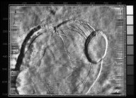
Mariner 9 image of the central caldera of the Martian volcano, Olympus Mons. the
basic morphology is similar to terrestrial calderas, although the scale is much larger. The smallest (and
youngest) collapse pit, at right, is 30 km across. Concentric fractures and terraces are visible in the
larger parts of the caldera. The caldera is about 29 km above the mean Martian surface. North is at 7:00.
(Mariner 9, MTVS 4265-52)
Date/Time (UT): 1972
Distance/Range (km): 4000.
Central Latitude/Longitude (deg): +18.,133
Orbit(s): 230
Imaging Information
Area or Feature Type: caldera, volcano
Instrument: 2-inch Vidicon Television Narrow Angle A-camera
Instrument Resolution (pixels): 700 x 832, 9 bit
Instrument Field of View (deg): 1.092 x 1.413
Filter: haze

High-resolution Mariner 9 image showing an area of irregular pits and
depressions near the south pole of Mars. The depressions have flat floors and smooth walls. Similar features
are formed on Earth by the scouring action of wind. The largest terrestrial example of these deflation
hollows, found in the desert of north central China, are still much smaller than those shown here. The frame
is about 75 km from top to bottom and is centered at 74 S, 7 W. (Mariner 9, MTVS 4270-24)
Date/Time (UT): 1972
Distance/Range (km): 3000
Central Latitude/Longitude (deg): -74., 007.
Orbit(s): 235
Imaging Information
Area or Feature Type: pit, depression
Instrument: 2-inch Vidicon Television Narrow Angle B-camera
Instrument Resolution (pixels): 700 x 832, 9 bit
Instrument Field of View (deg): 1.092 x 1.413
Filter: haze

Mariner 9 image of the north polar cap of Mars. The image was taken on 12
October 1972, about one-half Martian month after summer solstice, at which time the cap had reached its
minimal extent. The cap is about 1000 km across. The interior dark markings are frost-free sun-facing slopes.
A smooth layered sedimentary deposit underlies the cap. The image is centered at 89 N, 200 W. (Mariner 9,
MTVS 4297-47)
Date/Time (UT): 1972-10-12 T 20:52:51
Distance/Range (km): 9074
Central Latitude/Longitude (deg): +89.,200.
Orbit(s): 668
Imaging Information
Area or Feature Type: pole, polar, cap
Instrument: 2-inch Vidicon Television Narrow Angle A-camera
Instrument Resolution (pixels): 700 x 832, 9 bit
Instrument Field of View (deg): 10.50 x 13.56
Filter: polarizing
Illumination Incidence Angle (deg): N/A
Phase Angle (deg): 30.66
Instrument Look Direction: 35.47

A Martian shield volcano, approximately 25 miles across at the crater,
photographed consecutively by Mariner 9 with the wide-angle and telephoto lenses. The summit crater and
groves down the flank probably were produced by subsidence flowing subsurface movement of magma.

This mosaic of Mariner 9 frames (top), taken during the first orbit, shows the
remnants of the south polar cap of Mars dimly through the great dust storm. Mariner 7 photographed the same
area in August, 1969 (bottom) at which time the entire region was covered with dry ice. The strange
quasilinear features of 1969 have been replaced by a number of bright curved appendages never before seen on
Mars and, at this time, unexplained.

The most conspicuous feature yet observed on Mars by Mariner 9 is the darkish
spot located near the top of this picture. It has been tentatively identified as Nix Olympica, a curious
ring-shaped feature photographed by Mariners 6 and 7 in 1969 and a point which radar indicates is one of the
highest on Mars. One possible explanation suggests a high mountain or plateau which is being seen as it rises
up through the bright dust surrounding the rest of the planet. The picture, one of a series of 31 recorded on
the first tape-load during approach to Mars, was taken at 8:46 a.m. PST, November 11, 1971, at a range of
about 408,000 miles. North is at the top.

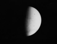
Mariner 9 took this picture of Mars at 3:38 a.m. PST, November 11, 1971., during
its approach to the planet. The south polar cap (at the bottom of the planet disc) shines dimly through the
apparent atmospheric haze, probably dust. This was the fourteenth picture taken during a 24-hour series of
Mars surveillance photos. The picture was taken with Mariner's narrow-angle camera from a distance of 445,000
miles. The "dust storm" has obscured the usually prominent Martian surface features from ground-based
observers for several months.

Mariner 9 took this picture of Mars during the closing hours of its approach to
the planet on November 13, 1971. The picture has been computer-enhanced with electronic high-pass filtering.
The crater-like object at the lower left is about 124 miles (200 kilometers) across and is the same dark spot
seen earlier in more distant views. It can be identified on a Mars map as Arsia Silva. The streaks pointing
north--more than 1000 kilometers long--are either atmospheric turbulence patterns or dunes formed downwind of
the crater. If they are dunes, they are as extensive as the largest in the Sahara in North Africa and those
in Peru, South America. The picture was taken from a distance of 65,000 miles about eight hours before
Mariner 9 went into orbit around Mars. It was transmitted back to Earth at 10:00 p.m. during the first
orbit.

In pictures taken early in the Mariner 9 mission, this region, shows a dark
mountain standing above the Martian dust storm. This higher resolution photograph shows that the area
contains a complex crater, called Olympus Mons (Nix Olympica or Snows of Olympus), nearly 64 kilometers (40
miles) in diameter. The multiple crater form with scalloped margins, is characteristic of calderas--volcanic
collapse depressions on Earth. In the Mariner 6 and 7 flights in 1969, an outer ring, 1600 kilometers (1,000
miles) in diameter, was seen. It is hidden by the dust in the oblique picture. Earth-based radar observations
show that this is a high region on Mars and is usually covered by a white cloud when observed telescopically.
This picture was taken on November 27, 1971.

Oblique view of the crater complex near Ascraeus Lacus in the Tharsis region of
Mars was taken by Mariner 9. It is the northernmost of the prominent dark spots observed by Mariner during
its approach to the planet. The spot consists of several intersecting shallow crater-like depressions. The
main crater is approximately 21 kilometers (13 miles) across, the whole complex about 40 kilometers (25
miles) across. The crater probably is in a relatively high area of the Martian surface, which accounts for
its being visible above the dust storm. The faint circular features outside the crater are probably
atmospheric.
