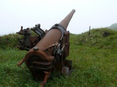
Kiska Island, July 2008

Back to the Aleutians
P1030696.JPG
This is a long drop -- 300 feet or so. I was surprised when I walked to the edge of one of those points in the thick fog.
P1030662.JPG
There are dozens of shipwrecks around Kiska island. Most are underwater. Some are barely underwater.
-map-
P1030663.jpg

-map-
P1030671.jpg

-map-
P1030672.JPG

-map-
P1030683.JPG
a nice rock
-map-
Kayak on Kiska Island
My Kayak on Kiska
-map-
P1030688.jpg
-map-
P1030700.JPG
There was a big field of Chocolate Lillies on North Head.
-map-
P1030706.jpg
This is the first woody plant we saw in Alaska. I think the root goes with the leaves on the right.
-map-
P1030707.jpg
A big gun in the fog
-map-
P1030714.jpg
Gun with gunner
-map-
P1030718.jpg

-map-
P1030732.jpg

-map-
P1030743.jpg
I think all these guns are Japanese. Some may have been made in Britain before the war.
-map-
P1030753.jpg

-map-
P1030770.jpg
6-inch or 15cm or 155mm artillery shell casings.
-map-
P1030771.jpg
The minnow and a wreck
-map-
P1030775.jpg
The minnow and the pier
-map-
P1030780.jpg

-map-
P1030790.JPG

-map-
P1030792.jpg
Another gunner
-map-
P1030796.jpg
Maybe that warning about live ammo was for real.
-map-
P1030801.jpg
That may be Segula Island in the distance
-map-
P1030808.jpg

-map-
P1030813.jpg

-map-
P1030817.jpg
There was a big field of Chocolate Lillies on North Head.
-map-
P1030823.jpg
This is what I could barely make out in the fog when I walked up to this edge. It was a big surprise!
-map-
P1030827.JPG

-map-
P1030835.jpg
My kayak
-map-
P1030842.JPG
Little Kiska Island
-map-
note: I left the GPS on the boat at Kiska, so the map link goes to our anchorage.