Alice Springs to Woomera, 12-4-07

Back to Driving Across Australia

P1200200.jpg
Most "pickups" are SUVs instead. But there are a lot of the cowcatchers and snorkels. A lot of the creek crossings have sticks with water depth marked on them so you can see how deep the water is before you cross. But there was no water in any of them now. It must be for the rainy season.
P1200201.jpg
IMG_0314.jpg
I think this is a Loran station, the gound-based GPS predecessor.

-map-
P1200208.jpg
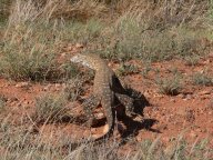
This guy is about 4 feet long.
P1200210.jpg
Someone is raising camels.
P1200215.JPG
Golahs
P1200226.JPG
P1200245.jpg
P1200247.JPG
P1200248.JPG
P1200249.JPG
P1200250.JPG
P1200253.jpg
This is a small bird.
P1200273.JPG
P1200281.JPG
P1200295.JPG
P1200316.JPG
P1200326.JPG
Ants and flowers
P1200339.JPG
Ants without flowers
P1200347.JPG
P1200351.jpg
IMG_0320.jpg
Mintabie, Opal town. Less than 100 people live there now, and most of those will leave on holiday when school is out.

-map-
IMG_0324.jpg
Mintabie

-map-
IMG_0325.jpg
Mintabie

-map-
IMG_0326.jpg

-map-
IMG_0327.jpg

-map-
IMG_0328.jpg

-map-
IMG_0329.jpg
A giant opal?

-map-
IMG_0330.jpg

-map-
IMG_0332.jpg

-map-
IMG_0337.jpg
Mintabie store.

-map-
P1200356.jpg
Mintabie
IMG_0340.jpg

-map-
IMG_0341.JPG

-map-
P1200360.jpg
There is no electrical service along most of the north-south highway, so the fiber optic repeaters (for voice and internet) use solar panels.
P1200361.jpg
There is no electrical service along most of the north-south highway, so the fiber optic repeaters (for voice and internet) use solar panels.
P1200363.jpg
Mirage
P1200367.jpg
Opal Fields
P1200368.jpg
Opal Fields
P1200370.jpg
Opal Fields
P1200371.jpg
Opal Fields
P1200382.jpg
Tree
P1200395.jpg
Bird
P1200396.jpg
No bird (except tail feathers)
P1200402.JPG
A bird
P1200404.jpg
A funny shaped ant hill. Maybe these are magnetic ants?
P1200405.jpg