Mars, by Mars Express
This full-colour image was taken by the High Resolution Stereo Camera (HRSC)
onboard ESA's Mars Express orbiter, in orbit 18 on 14 January 2004 from a height of 275 km. The resolution is
12 m per pixel.
The location is on the Martian equator north of Valles Marineris between 1° South to 2.5° North and 323° East. The area is 50 km across and shows mesas and cliffs as well as flow features indicating erosion by the action of flowing water. In this landscape view North is on the right. This image is also available in 3D.
The location is on the Martian equator north of Valles Marineris between 1° South to 2.5° North and 323° East. The area is 50 km across and shows mesas and cliffs as well as flow features indicating erosion by the action of flowing water. In this landscape view North is on the right. This image is also available in 3D.

Detail of the complex caldera of Olympus Mons
This vertical view shows the complex caldera at the summit of Olympus Mons on Mars, the highest volcano in our Solar System. Olympus Mons has an average elevation of 22 km and the caldera has a depth of about 3 km.
This is the first high-resolution colour image of the complete caldera of Olympus Mons. The colour image was taken from a height of 273 km in orbit 37 by the High Resolution Stereo Camera (HRSC) on ESA's Mars Express on 21 January 2004. The view is centred at 18.3°N and 227°E. The image is about 102 km across with a resolution of 12 m per pixel. South is at the top.
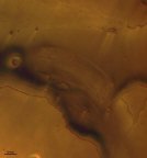
This vertical view shows the mouth of Kasei Vallis, one of the largest outflow
channels on Mars.
The image was taken by the High Resolution Stereo Camera (HRSC) onboard Mars Express in orbit 61 from an altitude of 272 km. The resolution is 12 m per pixel. The image centre is located at 29.8° north and 309° east, the image width is 130 km, North is up.
The part of the outflow channel seen in this image has most probably been carved by glaciers or gigantic water-related outflows from terrestrial subglacial lakes. The blackish-bluish colour is related to sediments. The bright streaks oriented NE-SW are related to wind forces.
This image has been selected for release because of the various details which give an insight into the erosional history of the outflow channel. The image also illustrates how difficult it is to achieve near-true colour in images of Mars when atmospheric dust and haze have a major disturbing influence on the scene.

This colour nadir (vertical view) image was taken during orbit 68 by the High
Resolution Stereo Camera (HRSC) on Mars Express, from an altitude of 271 kilometres.
The image is centred at 7.9 degrees North and 255.5 degrees East and shows a portion of the southern flank of Ascraeus Mons, the northernmost volcano of the Tharsis volcano group. North is at the right.
The lighter, 'pink' areas on the colour image are clouds. The peculiar depressions which can be observed here, and on several Martian volcanoes, are so-called 'lava tubes'. Lava tubes are caused by the crusting (or cooled lava) which occurs over a lava channel, a covering making the channel into a tunnel. When lava production ceases, the tunnel empties and the roof of the tunnel falls in, making an elongated depression.
Occasionally, the depression forms a chain of small pits over an emptied lava tunnel. Pit chains and lava tunnels are common on the Martian surface and are also seen on other terrestrial planets and the Moon.
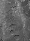
This image was taken by the High-Resolution Stereo Camera (HRSC) on Mars Express
in orbit 68 from an altitude of 271 km. The resolution is about 17 metres per pixel and shows a region called
Claritas Fossae on Mars, centred at 255.7° East and 30.9° North. North is on the left.
The Claritas Fossae are an ancient tectonic region west of Solis Planum, a tectonic and volcanic area south-east of the Tharsis volcano group.
The Claritas Fossae are an ancient tectonic region west of Solis Planum, a tectonic and volcanic area south-east of the Tharsis volcano group.
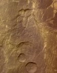

This image was taken by the High Resolution Stereo Camera (HRSC) on board ESA's
Mars Express during orbit 97 from an altitude of 269 kilometres. The image has a resolution of about 13
metres per pixel and is centred at 278.8° East and 8.3° South. North is at the right.
The image shows a system of sapping channels, called Louros Valles (named in 1982 after river in Greece), south of the Ius Chasma canyon which runs east to west. The Ius Chasma belongs to the giant Valles Marineris canyon system. The Geryon Montes, visible at the northern images border, is a mountain range which divide the Ius Chasma into two parallel trenches. The dark deposits at the bottom of the Ius Chasma are possibly related to water and wind erosion.
'Sapping' is erosion by water that emerges from the ground as a spring or seeps from between layers of rock in a wall of a cliff, crater or other type of depression. The channel forms from water and debris running down the slope from the seepage area. This is known from similar features on Earth, but on Mars it is thought that most of the water had probably either evaporated or frozen by the time it reached the bottom of the slope.

This image was taken by the High Resolution Stereo Camera (HRSC) on board ESA's
Mars Express during orbit 97 from an altitude of 269 kilometres. The image has a resolution of about 13
metres per pixel and is centred at 278.8° East and 8.3° South. The colour image has been created from the
nadir and three colour channels. North is at the right.
The image shows a system sapping channels, called Louros Valles (named in 1982 after river in Greece), south of the Ius Chasma canyon which runs west to east. The Ius Chasma belongs to the giant Valles Marineris canyon system. The Geryon Montes, visible at the northern images border, is a mountain range which divide the Ius Chasma into two parallel trenches. The dark deposits at the bottom of the Ius Chasma are possibly related to water and wind erosion.
'Sapping' is erosion by water that emerges from the ground as a spring or seeps from between layers of rock in a wall of a cliff, crater or other type of depression. The channel forms from water and debris running down the slope from the seepage area. This is known from similar features on Earth, but on Mars it is thought that most of the water had probably either evaporated or frozen by the time it reached the bottom of the slope.

This image was taken by the High Resolution Stereo Camera (HRSC) on ESA's Mars
Express during orbit 143 from an altitude of 266 kilometres. This image was taken with a resolution of about
25 metres per pixel and centred at 222° East and 22° North. North is to the right.
The image shows the western flank of the shield volcano Olympus Mons in the Tharsis region of the western Martian hemisphere. The escarpment at lower left rises from the surface level to over 7000 metres.
At the top of the image, part of the extensive plains west of the escarpment are shown, known as the 'aureole' (from the Latin for 'circle of light').
To the north and west of the volcano, these 'aureole' deposits are regions of gigantic ridges and blocks extending some 1000 kilometres from the summit like petals of a flower. The origin of the deposits has challenged planetary scientists for an explanation for decades.
The most persistent explanation, however, has been landslides. Large masses of shield material can be found in the aureole area. Several indications also suggest a development and resurfacing connected to glacial activity.
This colour image has been created from the nadir channel and three colour channels. Image resolution has been decreased to 50%.
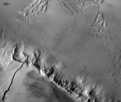
This image was taken by the High Resolution Stereo Camera (HRSC) on ESA's Mars
Express during orbit 143 from an altitude of 266 kilometres. This image was taken with a resolution of about
25 metres per pixel and centred at 222° East and 22° North. North is to the right.
The image shows the western flank of the shield volcano Olympus Mons in the Tharsis region of the western Martian hemisphere. The escarpment at lower left rises from the surface level to over 7000 metres. At the top of the image, part of the extensive plains west of the escarpment are shown, known as the 'aureole' (from the Latin for 'circle of light').
To the north and west of the volcano, these 'aureole' deposits are regions of gigantic ridges and blocks extending some 1000 kilometres from the summit like petals of a flower. The origin of the deposits has challenged planetary scientists for an explanation for decades.
The most persistent explanation, however, has been landslides. Large masses of shield material can be found in the aureole area. Several indications also suggest a development and resurfacing connected to glacial activity.
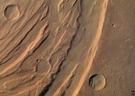
These images were taken by the High Resolution Stereo Camera (HRSC) on board
ESA's Mars Express are of the Acheron Fossae region, an area of intensive tectonic (continental 'plate')
activity in the past. Acheron Fossae marks the northern edge of the Tharsis plateau. It is part of a network
of extensional fractures that radiates outward from their central focus in the Tharsis 'bulge', a huge area
of regional uplift where intensive volcanic activity occurred. These curved 'faults' were caused in the
process of this uplift: cracks in the crust formed when the hot material rising from deep in the mantle of
Mars pushed the overlying 'elastic' lithosphere (surface layers of rock) upward. When the distorting tensions
became too strong, the brittle crust on top of the lithosphere broke along zones of weakness. Images 1-3,
from orbit 37, are dominated by these curved features, showing a highly fractured, faulted and deformed area
in the central part of the Acheron Fossae. The feature is situated at approximately 35º-40º North and
220º-230º East, about 1000 kilometres north of the large Olympus Mons volcano. For practical use on the
internet, the images have been reduced in their resolution - the data originally obtained from orbit at an
altitude of 765 kilometres (orbit 37) and 1240 kilometres (orbit 143) have a resolution of 30 metres and 50
metres per pixel respectively.
Colour picture of Gusev crater
This colour picture was taken by the HRSC camera on board ESA's Mars Express, from an altitude of 320 kilometres. It shows the centre of crater Gusev with the landing site of the NASA Spirit rover (marked). Gusev is a crater of 160 kilometres diameter. Earlier in the history of Mars, it appears that this area was covered by water. Because of the probable existence of sediments from this 'lake', Gusev is a highly interesting target in the search for traces of water and life on Mars. The area shown measures about 60 kilometres across at the bottom; North is at the top.
This colour picture was taken by the HRSC camera on board ESA's Mars Express, from an altitude of 320 kilometres. It shows the centre of crater Gusev with the landing site of the NASA Spirit rover (marked). Gusev is a crater of 160 kilometres diameter. Earlier in the history of Mars, it appears that this area was covered by water. Because of the probable existence of sediments from this 'lake', Gusev is a highly interesting target in the search for traces of water and life on Mars. The area shown measures about 60 kilometres across at the bottom; North is at the top.

This picture was taken by the High Resolution Stereo Camera (HRSC) onboard ESA's
Mars Express orbiter, in colour and 3D, in orbit 18 on 14 January 2004 from a height of 275 km. The location
is south of Valles Marineris at 15° South and 323° East. The resolution is 12 m per pixel, the area is 50 km
across and shows a tectonically controlled karst-like structure in a vertical view. North is at
top.
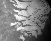
A partial (visible) view of the Martian south polar ice cap, taken on 11
February 2004 during orbit 103 by the High Resolution Stereo Camera on Mars Express, from an altitude of 269
kilometres light. The south pole is where the OMEGA instrument made its significant discovery, with the steep
slopes known as 'scarps' made almost entirely of water ice, falling away from the polar cap to the
surrounding plains, and the permafrost fields that stretch for tens of kilometres away from the
scarps.